This blog is open for anyone who can relay or needs information on any changes due to uplift and subsidence around the Sumatran islands. When you post, please leave your boat name, radio freq, and travel plans. This way, others can contact you at sea.
Click on the subject title (link) to go to the letter from the editor regarding the surfer/tsunami relief stories in the new issue of The Surfers Path!
The earthquake of April 10 (6.7 R, 17:29:11) in Siberut caused no human casualties and only limited material damage. In Muara Siberut, the buildings of the Junior High School (SMPN I) were damaged beyond repair. In Maileppet, most of the buildings in the National Park complex and buildings near and in the harbor complex were also seriously damaged. About 70% of the houses and offices in the National Park complex have been damaged beyond repair.
In the harbor, the pier has been uplifted (about 20 cm) but is still operational.
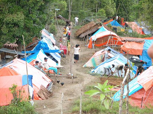
Since the earthquake of April 10, people in most of the coastal villages in Siberut have taken refuge and built makeshift camps in the hills close to their villages.
There are currently 16 IDP locations in the vicinity of Muara Siberut (the capital of the Sub-district of southern Siberut), where people have built makeshift camps with plastic covers. Most of the camps are located about one to two kilometers from the respective villages. Due to the continuing rains, the conditions in the camps are very muddy.
There is an acute shortage of mosquito nets, especially amongst the IDPs of Muara Siberut, increasing the risk of malaria. In the IDP camp of Lampu Mercusar, Muara Siberut, there are 17 mosquito nets for 667 IDPs.
Due to the earthquake, the Office of Education at district level (Dinas Pendidikan Tingkat II) closed all schools in Mentawai for a period of one week (April 10-April 17).
A large number of government officials, including medical staff from the Puskesmas, teachers and staff from the Sub-district Office in Muara Siberut, have fled to Padang after the April 10 earthquake. The absence of government officials makes it particularly difficult to develop a rapid response as well as monitor the conditions in the IDP camps.
No money has yet been allocated by the Head of the Mentawai district for relief activities.
Current situation:
Until now, the majority of the people taking refuge in the hills are still reluctant to return to their homes. During the last two days people have started slowly to pick up their daily lives again during the daytime, but still return to makeshift camps in the evening to spend the night in the hills.
Most IDPs have built semi-permanent tents in the hills in anticipation for future earthquakes.
The IDPs have not yet received any streamlined information regarding earthquakes and disaster mitigation from government agencies. The District Government has established a coordinating mechanism, Satuan Koordinasi Pelaksana (Satkorlak). However, no information regarding earthquakes and disaster mitigation plans has been disseminated until now.
Schools have reopened but many teachers are still absent, as most of them fled to Padang after the April 10 earthquake. The Junior High School (SMPN I) in Muara Siberut is still closed.
People in the IDP camps have difficulties to access clean water. Water resources are often located _ to 1 hour walking from IDP camps. In several IDP camps the water resources (i.e. rivers) have been polluted due to uncontrolled use of the water.
Shops have reopened since a few days and the stock of rice is sufficient to meet the current needs. However, it is expected that people will face difficulties in purchasing food as most of the economic activities have come to a halt.
Intervention:
Due to its long history in working with the national park in the Siberut Biosphere Reserve, UNESCO Office Jakarta has been able to play a crucial role in establishing a rapid response and monitoring the situation in the field. UNESCO has currently more than 20 project staff working in Siberut.
UNESCO conducted a rapid survey in the IDP camps in cooperation with governmental and non-governmental agencies, including Siberut National Park, Yayasan Citra Mandiri, SurfAid, Kirekat, Puskesmas Muara Siberut and the Head of the village of Muara Siberut.
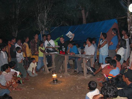
UNESCO, Siberut National Park and Yayasan Citra Mandiri have established three information centers to disseminate information and raise awareness regarding earthquakes and disaster mitigation. A rapid response team has been established and is currently visiting all the IDP camps to educate people in disaster mitigation as well as train IDPs on sanitation and waste management.
With the help from CEPF, UNESCO has set up tents in the most populated IDP camps as Lampu Mercusar, which are currently used by the Puskesmas (Community Health Centre) of Muara Siberut.
SurfAid International has provided 3000 mosquito nets to Mentawaians. The local SurfAid and UNESCO team as well as local NGOs will be responsible for the distribution of the mosquito nets in the 4 Mentawai sub-districts.
NGOs in Mentawai have agreed to freeze their programming for a period of four to six months and focus on education and mitigation.
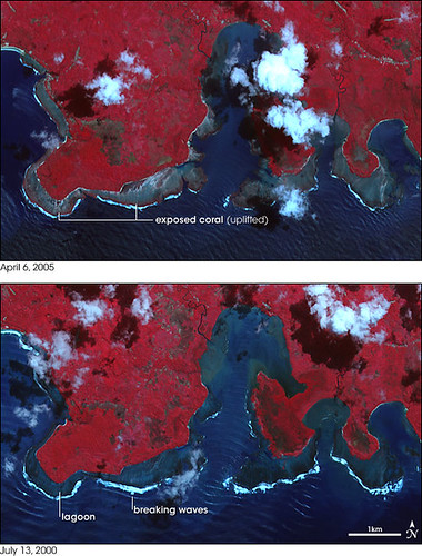
Before and after March 28th, the now uplifted reef off Southern Nias.
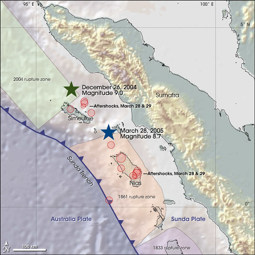
The pair of massive earthquakes near Sumatra, Indonesia, in late 2004 and early 2005, have reshaped the regional landscape. Uplift has raised coastlines out of the water in some areas, while subsidence (sinking) caused the sea to move farther inland in others. The first of the quakes struck on December 26, 2004, and generated a massive tsunami. Stresses from the magnitude 9.0 earthquake—the 4th largest since accurate seismic measurements began in 1900—triggered a second earthquake 200 kilometers (120 miles) to the south just three months later.
These images show uplift on the southern coast of Nias—an island 125 kilometers (80 miles) west of Sumatra. The epicenter of the magnitude 8.7 earthquake (seventh largest since 1900) of March 28, 2005, was approximately 150 kilometers (90 miles) to the northwest of these images (see map). Offshore coral reefs lie exposed in the image from April 6, 2005, compared to the suberged reefs (outlined by breaking waves) observed on July 13, 2000.
Both false-color images (composed of near-infrared, red, and green wavelengths of light) were acquired by the Advanced Spaceborne Thermal Emission and Reflection Radiometer (ASTER) aboard NASA’s Terra satellite. Red indicates vegetation, dark blue is ocean, aquamarine is shallow water or mud, bright cyan and white are clouds, and blue-gray is bare ground. The oceanside edges of the exposed coral may be covered in sea grasses, which would account for their red shading.
Field reports from United States Geological Survey scientists studying earthquake and tsunami effects document uplift of up to 2.5 meters (8 feet) and exposed coral reefs near these images on northern Nias. Both the earthquake and uplift were caused by the subduction of the Australia plate underneath the Sunda plate along a boundary called the Sunda Trench (see map).
Forces from deep within the Earth continuously drag the subducting plate (Australia) underneath the overriding plate (Sunda). Most of the time the plates remain relatively stationary, bound by friction between the rocks grinding together on either side of the boundary. Over hundreds of years, the stresses grow, gradually compressing the rock and dragging the lip of the overriding plate down towards the Earth’s interior with the subducting plate. The stresses eventually overcome the strength of the rocks at the plate boundary. The sudden release of energy sends waves through the Earth, felt as an earthquake on the surface. The leading edge of the overriding plate snaps upwards, raising the terrain above.
NASA image by Robert Simmon, based on data provided by the NASA/GSFC/METI/ERSDAC/JAROS, and U.S./Japan ASTER Science Team
Massive Earthquake Along the Sunda Trench Click here to view full image (2319 kb)
A magnitude 8.7 earthquake rattled northern Sumatra, Indonesia, on March 28, 2005, at 11:09 p.m., local time. At least 330 people are dead, but Indonesian officials expect the toll to soar over 2,000. The earthquake was centered 160 kilometers southeast of the 9.0 quake that triggered the devastating December 26,2004, tsunami, between the islands of Simeulue and Nias. The most severe damage appears to be on Nias, where large parts of the city Gunungsitoli were destroyed.
The United States Geological Survey reports that the March 28 quake occurred on the same fault that triggered the December 26 earthquake, probably as a result of stress placed on the fault by the first quake. The above map shows the locations of both earthquakes off the northwest coast of Sumatra. The March 28 earthquake occurred in a section of the fault just south of the part of the fault that slipped on December 26. The last time this section of fault moved was in 1861, when a large earthquake triggered a fatal tsunami.
As the image illustrates, the earthquakes occurred just east of the Sunda Trench, the deep underwater canyon where the Australia Plate is being pulled under the Sunda Plate. The plates, giant sections of the Earth’s crust, float on a layer of soft rock, propelled by convection currents beneath them. The Australia plate moves about five centimeters northeast in relation to the Sunda plate every year. As the Australia plate has crumbled under the Sunda plate, a number of faults have developed in the Sunda plate, including the thrust fault that produced both the December 26 and March 28 quakes.
According to the Pacific Tsumani Warning Center, sea level readings taken after the March 28 earthquake show that a small tsunami was generated, but there have been no reports of damage. Why did the 9.0 earthquake generate a massive tsunami compared to the small wave that came out of the most recent earthquake? By USGS estimates, both earthquakes occurred about 30 kilometers (18.6 miles) beneath the Earth’s surface, but the March 28 quake was much smaller and probably didn't displace the same amount of earth as the December 26 quake.
For more information about this earthquake, please visit the USGS Earthquake Hazards Program.
At the southern most end of the Cascadia Subduction Zone, off Northern California, is The Kings Range.
A very young, very steep and up to 4,000 foot high wild coastal range, created by the Mendocino Triple Junction where the Gorda Plate, North American Plate, and the Pacific plate meet. The San Andreas fault begins here, as does the CSZ.
I'd place big bets that these landslide prone, super heavy rainfall collecting young near vertical inclining mountains are more than capable of dramatically increasing the size of a locally produced tsunami.
Please share this sign, currently used in Oregon and Washington States, USA, with any local and government officials to adopt as Tsunami Hazard Zone signs. These can be posted along with signs that point to the local evacuation route (s).
Koen Myers of UNESCO, conducting an earthquake and tsunami education class on Siberut, Mentawais, April 2005, with materials from Kerry Sieh, Caltech, and Lori Dengler, Humboldt State University, California.
Tsunami Safety Information for the Mentawais, by Lori Dengler translated by Koen Myers
Pangasegekat kipa enungan tapurimanua ke’ bara onu (Tsunami). Pupaatuanan simatetek.
Ke’k nuorik kam moi sigegeugeu/teteu simaron, ola ake’ nueikam ka kudduat simareunan kabebet koat (kapatci) elek mei kakutduat simabuak simaruei. tupaatu momoi onu (Tsunami). Ke’k nuitco’ kam ikai oju simapali’ reunan (kai oju sitaimareirei tuitco’) kabuggei teret katengan koat sabbat makoinong bagat buggei, oto ola ake’ nueikam ka kudduat simareunan kabebet koat (kapatci) elek mei kakutduat simabuak simaruei. tupaatu momoi onu (Tsunami). Ke’k nuarep kam nganga sipuguguruk simaron sibara kakoat, oto ola ake’ nueikam ka kudduat simareunan kabebet koat (kapatci) elek mei kakutduat simabuak simaruei. tupaatu momoi onu (Tsunami). Anai maigi arut kakoat. Reuga’ ake’ kam tubumui kabebet koat simatata’ nia duanga jam tungena teret takbara arut koat minca. Ba’ pukutdu kam kabagat lalep simakakatai’ , kaoinan simalotik samba kagalajet simararagat teret ioi sipasirop ake’.
II. Pupaatuanan simananta nia pagalaijat sigegeugeu/teteu samba onu (Tsunami).
Anai bulat maigi sigegeugeu/teteu ka indonesia kalulut pukukutdu nia kalelengan gorot enungan sigegeugeu/teteu. Pagalaijat kerek nia enungan kipa ibara nusa-nusa kapolak Indonesia sipasi bailiu ake’ ibara sigegeugeu/teteu.Samba pigapa’ sigegeugeu/teteu nene momoi ibauliu sipasibara ake’ onu (tsunami). Simatatak nia kabagat senen dua ngarura, ai sigegeugeu/teteu sibailiu ake’ ibara/ ioi onu ka sara kutduat karirik buggei Indonesia, simaigi nia onu sigoisok tapoi anai leu et simabeuga’.
onu silelepa’ siooi kalaggo’ Desember 2004 situsabau, ai oi kalulut babara nia sigegeugeu/teteu. Sipuaali nene ia te enengan simareirei kapagalaijat polak.
Nusa-nusa nenda tak tulelelep kabagat koat! Sigegeugeu masiropakek masisuru ake’ minca nusa itubuak kautdut oinan. Senen sigegeugeu masibailiu ake’ isili pututubuat nusa (kenanen pagogoiso’), tapoi simareirei masibailiu ake’ katubuakat.
Kaoijanan samba kabaraijat Sigegeugeu elek onu tak momoi tuaagai. Samba kaoijanan nia minca tak momoi tuaagai. Kalulut puagaijat pagalaijat sigegeugeu samba onu lek momoi nupasikeli kap purimanuaijat mui samba sasaraina mui.
1. Pagalaijat kipa Masijago enganta saratta ke’ bara sigegeugeu. Sara lalep sitai maron tupaatu momoi mararagat kemoi sigegeugeu simaron. Bela kam kamatat pailingen elek kalaibok simaruei.
A. Onu (Tsunami) Geugeu polak iate patuagaijat kaooinia onu. Kenuorik kam sigegeugeu tubut simapali ron samba kateteret nenda aikam kabebet koat elek kabebet buggei, kenan kam simaruei kakudduat simareunan ka bebet koat elek kakutduat simabuak. Ukkakkam tatogamui mutuitui – ba’ pasisikeli kam bibilet, tarimeu samba pabagei-bagei pukaiyoat mui.
B. Kudduat siteu’k tue’ei : 30 ngameter buaknia keita sikuddu kabebet koat, 4 ngakilo kapatci elek kabaga bara nia kabebet koat kek kudduatta marata. Kek tak moi nueikam kasimareugak nenek, besik ake kam tubumui nuttut sioi nueikam. Sangamberi jaggauta tapanatra samba tatuitui simareunan irop akek sita. Kek tak momoi nueikam kakudduat simabuak gabakam samba kenan kam kalalep simabuak. Samba lue et pangaikat loina simabuak pasirom akek leuet sita. C. Tando sipoboikik ibara onu iate igarak akek oju simapalik, baeikam pasiabbut iba elek apa pak bagei. Kaojanan oinan minca isaliu nangkat pututuita. Tando sipoiki ibara onu iate nganga sipuguguruk sibara kakoat kelek ngangan kereta api elek ngangan tarabaeng sibara kakoat. Nenek iate katuagaijat kasita bulek tareugak ake tubutta kabebet koat nuttut nagka sioi tae’ei
D. Onu mareirei iabara akek pigapak betuet. Oinan moi samba mutuitui 3,4,5 nga minca elek legei. Samba leuet kaoijana arut koat moi pigangamenit pak (30 ngamenit/sangajam) kelepak ioi sigegeugeu. Simareirei nia onu mariuriu ioi ka ogga piga ngajam pak. Baei kam minca kabebet koat teret simatatania dua ngajam atukappluat onu. E. Senen-senen ibara sigegeugeu elek onu tauk makerek. Bui tak karoni baga betuet nia makerek senen-senen moi sigegeugeu. Momoi leuet onu bagei ibailiu mabuak elek marepek samba moi ibara akek sibabara kapiga pak kudduat imaron kalepakat nia. Pigapak sigegeugeu simarot tak aibabara akek onu simaron – tapoi kau ibailiu senen sigegeugeu kapolak iate sara pasirepdemen. Merupeilek marerei tatuitui kenanen tabara onu kepei tak tuagai sara sigegeugeu sipasibara akek onu sabeu.
F. Keatukapluat sigegeugeu. Kau taperepkam kakudduat kalaibo’ samba simalina teret lalep/bangunan tupaeru elek tuitcok kakataikatnia. Reugak akek kam tatoga kaoinan simalotik samba kakaraganan lalep. iapei minca simareirei bui tak babara sigegeugeu sikariuriugat nia simabeuga’ ele’ simagoiso’ bule masibara ake’ maigi simakatai’.