Tuesday, April 19, 2005

Bamboo Central


Bamboo Central, originally uploaded by Birdiez.

ENVIRONMENTAL BAMBOO FOUNDATION

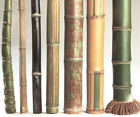
The Bamboo Nursery: With the help of LIPI's Dr. Elizabeth Widjaja and INBAR, EBF maintains a growing nursery to meet current and future needs for various planting projects. Started with eighty species of bamboo, EBF has successfully propagated more than 35,000 seedlings. While ensuring the propagation of all species, particular emphasis has been given to those most suitable for timber, shoot production and landscaping.

Where We've Been Where We Are Now Where We Are Going

HISTORY OF THE FOUNDATION

The Environmental Bamboo Foundation (EBF) is an Indonesian non-profit organization founded by designer Linda Garland in 1993 to protect tropical forests by promoting and demonstrating the many conservation and development opportunities that bamboo offers. In less than three years EBF has helped put bamboo on the conservation and development agenda of Indonesia while generating an international interest in bamboo that's growing exponentially. EBF, based in Bali, Indonesia has affiliate non-profit organizations in America (IBF), and Holland, also dedicated to spreading the news about bamboo.

The EBF has a focus upon international development, through consulting and education, preservation research, agro forestry projects, watershed reclamation, plantation development and policy development. Weekly educational workshops under the guidance of the staff of the Environmental Bamboo Foundation are ongoing in Indonesia. To date, all EBFand IBF board members have volunteered their time and resources to promote bamboo as an environmental solution. The EBF works in concert with the International Bamboo Foundation, the Zeri Foundation and an international network of bamboo associations, scientists, universities and governments.

EBF's main activities include:

* Design and marketing of locally produced, high quality bamboo products.
* Education and training in all aspects of bamboo production, from planting to marketing.
* Bamboo-based agro forestry and watershed rehabilitation.
* Applied research, information gathering and dissemination.
* Networking with government officials, entrepreneurs and bamboo experts.

EBF works in collaboration with:

* The Indonesian Government at national, provincial, district, sub-district, and village levels.
* International, national, and regional NGO's.
* International and national higher education and research institutions.
* Community groups.
* Private-sector entrepreneurs.
* Bamboo specialists from around the world.

WHERE WE'VE BEEN ...

The IVth IBC:

In 1995 the EBF hosted the IVth International Bamboo Congress, architectural forum, trade show and music festival in Bali, Indonesia. This four day world class environmental event drew over 2000 attendees from 37 countries. For the first time, the world's leading scientists, business representatives, engineers, architects, environmentalists and politicians participated together to promote bamboo as an environmental solution. This event was covered in Indonesia by CNN's Elsa Klench...

It was a landmark event when Indonesian Minister of the Environment, Sarwono

Kusumaatmadja, who officiated at the opening of the Congress, committed Indonesia to the "Zero Emissions" policy, after meeting with Gunter Pauli, co-author with Fritjof Capra of "Steering Business Towards Sustainability". In partnership with the IBF and EBF , Mr. Pauli, has since gone on to found ZERI (Zero Emissions Research Initiative). This effort has now created standards for industrial reform worldwide of the recycling of waste and reduction of CO2 emissions. This event was one example of the diverse range of environmental solutions explored and launched at the conference.


Training Center at Penglipuran:

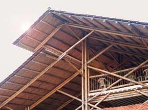
In 1994 a fully equipped training center , surrounded by bamboo gardens and nurseries, was created in Penglipuran. Its facilities include classrooms, workshops, an office, a dormitory, and a kitchen. Equipment at the center includes basic tools and machines for bamboo preservation and making ply-bamboo. The Center is managed cooperatively with the Penglipuan community, who contributed land and labor for its construction. Funding for this project came from a grant from USAID and the Earth Love Fund (UK).

Training Indonesia's First Group of Bamboo Trainers

In early 1995 the Bamboo Training Center in Penglipuran hosted thirty people from NGOs and government agencies in Indonesia, who were trained in all aspects of bamboo cultivation, production, and marketing. After the program, participants returned home with locality specific bamboo action plans including agro forestry and watershed protection, as well as production and marketing of bamboo products. EBF intends to provide continued technical and marketing support to this first group of trainers, as well as to training of an additional group in 1996.

Supporting Indonesia's National Bamboo Development Strategy

As a direct result of the IVth International Bamboo Congress, Festival and Trade Show, the Government of Indonesia's commitment to bamboo for conservation and development has been solidified. In late 1995, bamboo was declared a multi-purpose species, thus opening the way to research and development for bamboo applications in the Departments of Agriculture and Forestry. In February 1996, the government initiated the National Bamboo Development Strategy, coordinated by the Ministry of the Environment and Department of Forestry, including representatives from nine Ministries and Departments. EBF is pleased to have been invited to take an active role in the implementation of Indonesia's National Bamboo Development Strategy Program.


WHERE WE ARE NOW...

Establishment of Bamboo Based Agro forestry Projects
The EBF has initiated three bamboo based agro forestry projects in Bali. One site is located ion community land managed through traditional community institutions (Tanah Adat), and is operated both as a producing plantation and as a demonstration plot in cooperation with local farmers. The second project is located on degraded forestland and is managed in collaboration with the Department of Forestry. Active on these projects are scientists from the Indonesian Institute of Science (LIPI), Udayana University professors and students, government officials at the national, provincial and local level, representatives from Indonesian NGO's and community groups.

These seemingly modest projects far reaching effects have already fostered:

* Formation of a special team of Indonesian scientists who will develop onsite applied research to extensive bamboo cultivation throughout Indonesia.

* Training opportunities for government and NGO field workers, and local farmers who are learning new techniques adaptable for other areas

* Generation of Indonesia's first set of comprehensive data (to be completed within five years) to support the overall expansion of bamboo production throughout Indonesia.

WHERE WE'RE GOING ...

Boucherie Bamboo Preservation

The powder post beetle continues to inhibit the potential of bamboo export market development. In collaboration with Professor Walter Liese, an EBF board member and the world's leading expert in bamboo processing, EBF has developed a treatment process that eliminates this problem by replacing the sweet sap in bamboo with an eco-friendly preservative that repels insects. This year, we will continue researching the viability of this system and develop a prototype that can be used by entrepreneurs for income generation in through out Indonesia and internationally. Concurrently, the EBF will train NGO's community groups and entrepreneurs interested in establishing their own treatment facilities. Finally in collaboration with the Penglipuran community, EBF will begin selling treated bamboo in order to demonstrate the feasibility of the Boucherie process as a distinct business and to generate revenues to sustain the foundations work.

The Bali Nursery and Collection Garden

EBF is working with the Government of Indonesia to establish Bali's Bamboo Collection Garden, one of seven such gardens to be set up across the nation to conserve bamboo stock, provide research and education opportunities, promote ecotourism, and generate income from a visitor's entrance fee as well as from the sale of bamboo plants. The Bali Bamboo Collection Garden will be established at the EBF Training Center in Penglipuran and will eventually include species traded from six other Indonesian collection gardens.


Charitable Contributions are acknowledged by a receipt for tax deductions over USD$300 Thank you for your support

EBF - Bali P.O. BOX 196, Ubud, Bali Indonesia 80571 Phone: 62 361 974 028 Fax: 62 361 974 029

Sunday, April 17, 2005

Car Nicobar


Nicobar, originally uploaded by Birdiez.

Car Nicobar stilt dwellings 1809 engraved by J.Fittler after a picture by H.Salt (Valentia, 1811). Architectural features of the houses are well adapted to modest storm surges, and the 1881 earthquake resulted in shoreline flooding of the stilts to the floor levels only (Oldham, 1884).

- If I am not mistaken - those look like giant timber bamboo growing!

Saturday, April 16, 2005

Onolimbu - sunken


Onolimbu, originally uploaded by Birdiez.

This looks like the soil was shaken and compacted down, putting pressure on a very high water table, which was forced up.

These buildings sank into the mud, and it looks like a new tidal flat was created from the combination of liquefaction, subsidence, a high water table, and the sea now able to spread into the area.

These are the sort of processes that create bays and lagoons. Exciting stuff.

Lateral spreading and sand boils can probably be found in the area, and I am curious to see what a full geological survey will reveal.

Onolimbu is on the eastern coast of Nias, between the two major ports of G.S to it's north, and T.D on the southern tip.

I assume it is this situation, that caused the rumor that Nias was sinking.

It isn't.

This is a common occurance, in these types of low lying areas, bordering rivers and coastlines, with soft gradular soils, in major earthquakes.

Nature's landscape artist has obviously been hard at work!

Making a new bay or lagoon in a matter of minutes ;-)

Picture taken by Rick Cameron - © 2005

Sand Boil


Sand Boil, originally uploaded by Birdiez.

This is a really fantastic shot of a sand boil!

During an actual earthquake, a liquid mixture of sand and water would have been gushing out of this, leaving the sand deposited in the cone formation.

If you see any of these, please take a picture and make a note of it's location.

Sand Boils occur during liquefaction, and are commonly found in river delta's, low lying basins, and anywhere where there is loose grandular soils, and a healthy water table.

Lateral Spreading


Lateral Spreading, originally uploaded by Birdiez.

This is an example of lateral spreading, which occured during an earthquake in Guateumala.

See the fissures running alongside the river? When you scroll down the blog, to the traditional house with the fissures running along side it, compare to these.

Lateral Spreading can occur during liquefaction.

If you see these types of fissures in places where there may be a swamp/river/low lying basin or high water table - soft soils, please make a note/picture of it.

Bamboo Structure


Bamboo House, originally uploaded by Birdiez.

Giant Bamboo can make for some beautful buildings~

Friday, April 15, 2005

Onolimbu area/Nias


Onolimbu area/Nias, originally uploaded by Birdiez.

This photo by Rick Cameron shows two big ground fissures, running right alongside a traditional house in the area of Onolimbu, Nias.

These fissures look to be the result of lateral spreading, created by liquefaction.


Note the giant bamboo foundation it is built upon.

Great example of why bamboo is so excellent!

Reconstruct with Bamboo


Reconstruct with Bamboo, originally uploaded by Birdiez.

Behavior in earthquakes or hurricanes

In case of a dynamic overload, as it occurs in earthquakes and hurricanes, following reactions can be realized: Statistically steel fails before concrete does and if steel failed long ago and 80 percent of the concrete constructions collapsed, then only 10 percent of the constructions of bamboo and wood would fail, see diagram!

Another advantage of bamboo, which is not taken into account in the statistical consideration before, is the absorption of energy in the joints. At excessive load, about 85 percent of the energy is used for the deformation of the joints, and only 15 percent cause elastic bending of the material.

Bamboo keeps helping after the earthquake, too!

As the forests are in peril in Indonesia, the villagers are poor, Giant Bamboo is the answer all the way around. It is the strongest most flexible material for building in a earthquake zone, it can grow more than a metre a day, new shoots can be started by cuttings, it makes a terrific barrier against wind and possibly, wild pigs and tsunamis (like the mangrove forests).

I have contacted Paul Wandera at Bamboo Kenya (click on title link) to see if I can hook him up with IDEP, Howu-Howu, SAI, and Surfzone Relief.

Bali is a major consumer and user of Bamboo, and IDEP is based there. I am hoping we can get some shipments of cured giant bamboo for building started for the villages, as well as the delivery of cuttings so they can start to grow it. Birdie (see below for more from Paul's site)

Bamboo is many things to many people.

It is apparent that the bamboo can play an important role in the development of the country’s economy and especially the rural economy by generating entrepreneurship and employment. The potential has however not been recognized.

WHO WE ARE

Bamboo Kenya was founded by, Paul Wandera an architectural technician and bamboo enthusiast. We are eager to share what we know, to educate and teach people about bamboo. Bamboo Kenya has visions and ambitions for the broadened use of bamboo in Kenya looking for sustainability and visibility. We want to focus our energy solely upon finding a solution to, environmental concerns regarding the diminishing forest resources in Kenya and to inform people about bamboo as an environmentally renewable non-wood forest resource. Apart from this Bamboo Kenya would like to start informative educational programs on bamboo that will protect tropical forests by promoting and demonstrating the many conservation and development opportunities that bamboo offers. We will strive to promote the use of bamboo and educate others about the greatly misunderstood and underutilized benefits of using and preserving this plant. One of the main ways in which we hope to accomplish this is through our educational and our consultant services and by your continued participation and support.

Bamboo is a survivor it bends but it doesn’t break.


Thursday, April 14, 2005

Camp "Stone Graph" & baby elephant seal

This is Camp Stone Graph, at Leo Carrillo State beach in Southern California. The shelter is amazingly well built, big, cool and blocks the wind...

The baby elephant seal was hauled out here with a family harassing it by putting water on it, and not allowing it to sleep. I made them step back, drew a large circle around it, and phoned it in to the Marine Mammal Rescue - where, I was trained to do rescues and am on call with - and - they came down with a kennel carrier, the lifeguard w/truck, and we got the baby into the kennel and up on the truck. This took awhile. So, I was slow getting around to starting on the Stone Graph beta test. I go back tomorrow. The baby seemed to be missing an eye, and is at the marine hospital.

One type of graph I will build, will be a scale of magnitudes/felt intensity to show at what point on the scale a tsunami can be created. This is an easy stone graph to build which will teach people how big an eq needs to be to create a tsunami.

The aftershock graph is more labor intensive and requires more design and rocks!!!!!!!!!!

I have to base it on a general conversion from magnitude to felt intensity (modified mercalli scale). Obviously, villagers living on or near swamp or old river bed will have experienced far more intensity in shaking than other villagers living on firmer ground. Each village can only build a graph based on the soil they live on, and what they felt. So, it will be entirely subjective to where they are. I can only create a general conversion from M to MMI, to get them started.


Maybe the villagers that make tattoo's will be into building these, with the village masons.

I am also designing beaded necklace type of strands, for M & MMI scales, and - aftershock sequences. They will love these on the Mentawais, as they believe that by making themselves beautiful with tattoo's, beaded necklaces, leaves and flowers in their hair, their spirits will not wander away from them - in search of a more beautiful place - and therefore, they will stay healthy and alive.

Of course, the stone graph (in Nias, they are very into stone work) and the beads are being designed to help educate them about eq's and to introduce record keeping methods for them. The education will help keep them safe, healthy, and alive, even in big earthquakes. So, they'll relate to them, just fine.

The overall goal, is to develop a way for them to keep a record, based on what they felt, and to use that record to teach them more about earthquakes, especially in relation to building and tsunami safety. I can use blue beads when the M or MMI is enough to create a tsunami, etc.

I'll post more, as things develop.

3/28 aftershock sequence - in stones

This represents only about half of the aftershocks of 28 March. Note the wood & stone marking the 8.7M to start it off...I could have done with a bigger boulder!

See the graph in the shadows?

Most of the aftershocks were in the 4.5 - 5.2 range. You'll notice when a 6M appears or a 4.4M.

The Modified Mercalli Intensity Scale

The effect of an earthquake on the Earth's surface is called the intensity. The intensity scale consists of a series of certain key responses such as people awakening, movement of furniture, damage to chimneys, and finally - total destruction. Although numerous intensity scales have been developed over the last several hundred years to evaluate the effects of earthquakes, the one currently used in the United States is the Modified Mercalli (MM) Intensity Scale. It was developed in 1931 by the American seismologists Harry Wood and Frank Neumann. This scale, composed of 12 increasing levels of intensity that range from imperceptible shaking to catastrophic destruction, is designated by Roman numerals. It does not have a mathematical basis; instead it is an arbitrary ranking based on observed effects.

The Modified Mercalli Intensity value assigned to a specific site after an earthquake has a more meaningful measure of severity to the nonscientist than the magnitude because intensity refers to the effects actually experienced at that place. After the occurrence of widely-felt earthquakes, the Geological Survey mails questionnaires to postmasters in the disturbed area requesting the information so that intensity values can be assigned. The results of this postal canvass and information furnished by other sources are used to assign an intensity within the felt area. The maximum observed intensity generally occurs near the epicenter.

The lower numbers of the intensity scale generally deal with the manner in which the earthquake is felt by people. The higher numbers of the scale are based on observed structural damage. Structural engineers usually contribute information for assigning intensity values of VIII or above.

The following is an abbreviated description of the 12 levels of Modified Mercalli intensity.


I. Not felt except by a very few under especially favorable conditions.

II. Felt only by a few persons at rest, especially on upper floors of buildings.

III. Felt quite noticeably by persons indoors, especially on upper floors of buildings. Many people do not recognize it as an earthquake. Standing motor cars may rock slightly. Vibrations similar to the passing of a truck. Duration estimated.

IV. Felt indoors by many, outdoors by few during the day. At night, some awakened. Dishes, windows, doors disturbed; walls make cracking sound. Sensation like heavy truck striking building. Standing motor cars rocked noticeably.

V. Felt by nearly everyone; many awakened. Some dishes, windows broken. Unstable objects overturned. Pendulum clocks may stop.

VI. Felt by all, many frightened. Some heavy furniture moved; a few instances of fallen plaster. Damage slight.

VII. Damage negligible in buildings of good design and construction; slight to moderate in well-built ordinary structures; considerable damage in poorly built or badly designed structures; some chimneys broken.

VIII. Damage slight in specially designed structures; considerable damage in ordinary substantial buildings with partial collapse. Damage great in poorly built structures. Fall of chimneys, factory stacks, columns, monuments, walls. Heavy furniture overturned.

IX. Damage considerable in specially designed structures; well-designed frame structures thrown out of plumb. Damage great in substantial buildings, with partial collapse. Buildings shifted off foundations.

X. Some well-built wooden structures destroyed; most masonry and frame structures destroyed with foundations. Rails bent.

XI. Few, if any (masonry) structures remain standing. Bridges destroyed. Rails bent greatly.

XII. Damage total. Lines of sight and level are distorted. Objects thrown into the air.

------------------------------------------------------------------------
Abridged from The Severity of an Earthquake, a U. S. Geological Survey General Interest Publication.

U.S. GOVERNMENT PRINTING OFFICE: 1989-288-913

------------------------------------------------------------------------

This publication is one of a series of general interest publications prepared by the U.S. Geological Survey to provide information about the earth sciences, natural resources, and the environment. To obtain a catalog of additional titles in the series "General Interest Publications of the U.S. Geological Survey," write:
U.S. Geological Survey
Information Services
Box 25286
Denver, CO 80225

See title link for more info on magnitudes and intensity.


Wednesday, April 13, 2005

Talang


Buusung uplift and Talang, originally uploaded by Birdiez.

Talang, Sumatra, Indonesia
Location: 1.0S, 100.7E
Elevation: 2,896 m


Talang is a stratovolcano with 8 confirmed eruptions between 1833 and 1968. The volcano may have had a phreatic eruption in 1986 but the activity has not been confirmed. Most of the eruptions are moderate in size (VEI=2) and explosive. Eruptions in 1833, 1843, 1845, and 1876 were from flank vents. An eruption in 1967 and two different eruptions in 1968 were from radial fissures. The distance from the city of Padang to Talang is about 35 km. Image courtesy of the Landsat Pathfinder Project.
------------------------------------------------------------------------
Source of Information:

Simkin, T., and Siebert, L., 1994, Volcanoes of the World: Geoscience Press, Tucson, Arizona, 349 p.

------------------------------------------------------------------------

Talang, which forms a twin volcano with the extinct Pasar Arbaa volcano, has two crater lakes on its flanks. The largest of these is 1 x 2 km wide Danau Talang. No historical eruptions have occurred from the summit of the volcano, which lacks a crater. All historical eruptions from Gunung Talang volcano have involved small-to-moderate 19th-century explosive activity originating from a series of small craters in a valley on the upper NE flank.

Sunday, April 10, 2005

Traditional Nias Village - pre-earthquake

Traditional Nias Villages

Traditional Nias Village - pre-earthquake

Traditional Nias Villages

Women in Siberut

(no subject)

Men in Siberut

(no subject)

Uplift at Pulau Tepak in southern Simeulue


RickApril07Tepakuplift, originally uploaded by Birdiez.

The shot was taken at high tide at Pulau Tepak in southern Simeulue. For reference, typical high tides would lap at the foundation of the house at the tree line before March 28. In an area where navigating, dockings, and beach landings were difficult BEFORE the quake, getting a boat close to land with relief and aid materials is nearly impossible now. Moving the boats at night is extremely high risk, so the window of time to get in and help is greatly shortened. Its made the use of smaller boats and local fishermen imperative in order to reach the larger boats and carry in the goods bit by bit.
©2005 Rick Cameron 7 April

What to Expect: Aftershock Sequences

Aftershocks to the Sumatran Earthquake

April 11, 2005
Lucy Jones
Scientist-in-charge for Southern California, U. S. Geological Survey

Like all big earthquakes, the December 26, 2004 and March 28, 2005 Sumatran earthquakes have been followed by a sequence of aftershocks. Scientists have shown that aftershocks follow predictable patterns and have developed equations to describe those patterns. The Sumatran aftershocks are following those patterns and from this we can predict how many aftershocks can be expected over the next year.

Aftershocks usually occur geographically near their mainshock. The stress on and around the mainshock's fault changes during the mainshock and that fault and its nearest neighbors produce most of the aftershocks. Aftershocks are other earthquakes triggered either on the mainshock fault or at a distance from the mainshock fault no greater than the length of that fault. Because the December fault segment was so long (1200 km), any earthquake within 1,200 km of the fault fits the standard definition of aftershock. The March 28 earthquake occurred on an adjacent segment of the same fault that produced the December event,

The rate of aftershocks dies off quickly with time so even the second day will have many fewer aftershocks than the first. Approximately, the second day has half the number of the first, the third day has one-third the number of the first, etc. We call an earthquake an aftershock as long as the rate of earthquakes in the area is greater than it was before the mainshock. How long this lasts depends on the size of the mainshock (bigger earthquakes have more aftershocks) and how active the region was before the mainshock (if it was quiet, the aftershocks continue to occur above the previous rate for a longer time). It could be a decade or more for the Sumatran earthquakes.

Aftershocks come in all magnitudes, but smaller magnitudes are much more common. The relative number of small to large aftershocks in the Sumatran sequence is very close to the worldwide average and implies 1 magnitude 6 event for every 100 magnitude 4 events. By fitting an equation to the 3 months of aftershocks we have already recorded, we can estimate the probability of more large earthquakes in the next two years. At this rate, we have about a 1 in 8 chance of another magnitude 8 somewhere in the region in the next two years and a 1 in 3 chance of a magnitude 7.5 in the same time.

Birdie here:

Ok - one way to do this is to take a coconut or a Big Rock. put it on the sand. That's our 9M. If you have the fault map, draw the main faults in the sand...but that will be to explain "Where", which is a different, but related subject. Let's start with time then, move on to space :-)

For the concept of understanding this is about *When*, make one long pathway, starting with The Big Rock. Have everyone help you get a lot of rocks. lots and lots and lots and lots of smaller ones. A few medium ones. Find one that is the 8.7M. Find another that could be a 8 or 7.5. Make your time line - aftershock sequence two years long. The distance between Dec 26th & March 28th is 3 months. Move the 8M or the 7.5 around down the line, as if to say...maybe here? maybe there? maybe like this (8M) or maybe like this (7.5) make sure the bigger they are - the most little and medium rocks they have clustered right along them...and then finish with a trail of a few 6M rocks and all kinds of smaller ones....til they trail off...make them smaller and farther apart...

If you want to draw the whole fault line and draw where the islands are, in the sand, then, pick up all the rocks and put them where they would be on the actual aftershock map...fine, but I don't think anyone has the time!! Best to wait for summer for that...

Any rock the size of a 6M or bigger - you can use to show that a 6M > could damage a weak building or other unsound stucture. Otherwise, they are not that big a deal.

This will be best done after supplies have been unloaded, and a meal has been had by all.

There you go.

Should work for beach landings.

I'm running down to the beach today 4/13 to make a model of this in the sand with stones - will post pictures. I am using various data from this post and the USGS.

Birdie


Click on the title to find the current up-to-date eq map and list


Friday, April 08, 2005

Tsunami Safety Info - english/indo

Click on title for a Nova Q&A with tsunami expert, Lori Dengler

Please feel free to copy and distribute:

Short versions and long versions below

Tsunami safety information

Shorter Version

- If you feel a strong earthquake, go inland or move to higher ground immediately. A tsunami may be coming.
- If you see the ocean water draw far down and expose the seafloor, go inland or move to higher ground immediately. A tsunami may be coming.
- If you hear a loud roar from the coast, go inland or move to higher ground immediately. A tsunami may be coming.
- There may be many waves. Stay away from the coast until at least 2 hours have past with no wave activity.
- Stay outside away from damaged buildings, dirty water and debris until help arrives.

Informasi mengenai keselamatan terhadap ancaman Tsunami.
Versi yang yang lebih pendek.
- Jika anda merasakan getaran gempa bumi yang kuat, maka pergilah ke daerah pedalaman atau bergerak ke tanah yang lebih tinggi dengan segera. Kemungkinan tsunami akan datang.
- Jika anad melihat air samudera bergerak jauh ke tengah lautan dan memperlihatkan dasar laut, maka pergilah ke daerah pedalaman atau bergerak ke tanah yang lebih tinggi dengan segera. Kemungkinan tsunami akan datang.
- JIka anda mendengar suara gemuruh keras dari pantai, maka pergilah ke daerah pedalaman atau bergerak ke tanah yang lebih tinggi dengan segera. Kemungkinan tsunami akan datang.
- Ada banyak gelombang laut. Jauhilah pantai sampai paling sedikit 2 jam berlalu tanpa kegiatan gelombang laut.
- Tinggal di luar jauh dari bangunan yang rusak, air kotor dan puing-puing reruntuhan sampai bantuan tiba.

By Dr. Lori Dengler - Tsunami Expert http://www.pbs.org/wgbh/nova/tsunami/ask.html

Longer Version
1) About earthquakes and tsunamis

Indonesia has many earthquakes because of its geologic setting. The same natural processes that build the Indonesian islands cause earthquakes. Some of these earthquakes cause tsunamis. On average, every 2 years an earthquake causes a tsunami somewhere on the Indonesian coast. Most are small but some are large. The December 2004 tsunami was caused by an earthquake. It was a natural phenomenon.

The islands are not sinking into the sea! Earthquakes are helping to build the land up. Each earthquake affects the islands a little differently, but the general pattern is up.

Earthquakes and tsunamis cannot be predicted. We don't know when the next one will happen. Become educated and you can save yourself and your family.

2) Protecting yourself during an earthquake
A weak building may collapse in the strong shaking. Move into the doorway or outside if you can.

3) Tsunamis
Ground shaking is a natural warning of a tsunami. If you feel a very strong earthquake and you are on the beach or near the coast, go inland or to higher ground as soon as you can. Take your children and go - don't gather your belongings, save animals or do anything else.

Safe zones: 30 meters above the sea level if you are on the coast, 4 km away from the beach if the land is flat. If you can't go this far or this high, go as far as you can. Every step up or inland will help you. If you are cut off from higher ground, go to the third floor or higher of a strong building. Even climbing a tree may save your life.

The first sign of a tsunami may be the water draining out like a very low tide. Do not go down to the beach to pick up fish or shells. The water will come back much faster than you can run.

Sometimes the first sign of a tsunami is a loud roar like a train or a jet plain coming from the ocean. This is your warning to move away from the coast as fast as you can.

Tsunamis always have several waves. The water may go in and out 3, 4, 5 or more times. Sometimes waves arrive only a few minutes apart but often the time is much longer - 30 minutes or even 1 hour. Waves may continue to arrive for many hours. Do not go back to the coast until at least 2 hours have passed with no waves.

Each earthquake and tsunami is unique. Don't expect the waves to be the same every time an earthquake happens. The next one will be higher or lower and may affect some areas more strongly than the last one. Some strong earthquakes won't cause a big tsunami - but always take the ground shaking as a warning. It is better to evacuate many times for no waves than to miss one earthquake that causes a big tsunami.

4) After the earthquake is over
Sleep outside until buildings are repaired or checked for damage. Keep children away from dirty water and debris. There will be aftershocks and some will be strong enough to cause more damage.

Use buckets or bowls to collect fresh rainwater for drinking and washing.

If wells are dry - Dig down into them until you hit water.

Help is on the way


Versi yang lebih Panjang

Tentang gempa bumi dan tsunami.

Indonesia mempunyai banyak gempa bumi oleh karena letak geologisnya. Proses alam yang sama yang menciptakan kepulauan Indonesia menyebabkan timbulnya gempa bumi. The same natural processes that build the Indonesian islands cause earthquakes. Beberapa gempa bumi ini menyebabkan tsunami. Rata-rata , setiap 2 tahun sebuah gempa bumi menyebabkan gempa bumi tsunami di suatu tempat di pantai Indonesia. Sebagian besar kecil namun ada beberapa yang besar. Tsunami yang terjadi pada bulan Desember 2004 disebabkan oleh gempa bumi. Hal itu merupakan suatu fenomena alamiah.

Pulau tersebut tidak tenggelam ke dalam lautan ! Gempa bumi membantu membangun kembali daratan ke atas. Setiap gempa bumi mempengaruhi pulau sedikit berbeda, tetapi pola umum yang terjadi adalah ke atas.

Gempa bumi dan tsunami tidak dapat diprediksi. Kita tidak mengetahui bila gempa bumi berikutnya akan terjadi. Dengan bekal pendidikan untuk mengetahuinya, maka anda dapat menyelamatkan diri anda sendiri dan keluarga anda.

2) Melindungi anda sendiri selama terjadinya suatu gempa bumi.
Suatu bangunan yang rapuh ada kemungkinan runtuh dalam guncangan yang keras. Bergeraklah ke pintu keluar atau berjalan ke luar jika anda dapat.

3) Tsunami
Guncangan tanah merupakan peringatan alamiah akan suatu gelombang tsunami. Jika anda merasakan suatu gempa bumi yang sangat keras dan anda sedang berada di tepi pantai atau di pesisir, pergilah ke daerah pedalaman atau ke tanah yang lebih tinggi secepat-cepatnya. Bawalah anak-anak anda dan pergilah – jangan mengumpulkan milik anda, menyelamatkan binatang ataupun melakukan hal lainnya.

Zone aman : 30 meter di atas permukaan laut jika anda berada di daerah pesisir, 4 km jauhnya dari tepi pantai jika daratannya rata. Jika anda tidak dapat pergi sejauh ini atau setinggi ini, maka pergilah sejauh anda dapat. Setiap langkah menaik atau ke daerah pedalaman akan menolong anda. Jika anda tidak dapat menjangkau ke tanah yang lebih tinggi, maka pergilah ke lantai tiga atau yang lebih tinggi dari suatu bangunan yang kuat. Bahkan memanjat pohon dapat menyelamatkan jiwa anda.

Tanda pertama dari tsunami dapat merupakan penyedotan atau pengeringan air seperti sebuah gelombang pasang surut. Jangan pergi ke pantai untuk mencari ikan atau kerang. Air akan kembali lagi jauh lebih cepat ketimbang anda dapat lari.

Kadang kala tanda pertama dari tsunami adalah suara gemuruh keras seperti kereta api atau pesawat jet berasal dari samudera. Ini adalah peringatan bagi anda untuk bergeak ke luar dari pesisir secepat anda dapat.

Tsunami senantiasa memiliki beberapa gelombang laut. Air dapat masuk dan keluar 3,4,5 kali atau lebih. Kadang kala gelombang laut tiba hanya beberapa menit secara terpisah atau tersendiri namun acapkali waktunya jauh lebih lama - 30 menit atau bahkan 1 jam. Gelombang laut kemungkinan terus dating selama berjam-jam. Jangan pergi kembali ke daerah tepi pantai sampai paling sedikit 2 jam berlalu tanpa kegiatan gelombang laut.

Tiap gempa bumi maupun tsunami adalah unik. Jangan berharap bahwa gelombang lautnya sama setiap kali terjadi gempa bumi. Gelombang laut yang berikut akan lebih tinggi atau lebih rendah dan dapat mempengaruhi beberapa daerah secara lebih kuat daripada yang terakhir. Beberapa gempa bumi kuat tidak akan menyebabkan tsunami hebat – namun senantiasa anggaplah guncangan pada tanah sebagai suatu peringatan. Lebih baik mengevakuasikan banyak kali selama tidak timbul gelombang laut daripada tidak menjumpai satu gempa bumi yang menyebabkan tsunami yang besar.

4) Sesudah gempa bumi berlaku.
Tidurlah di luar sampai bangunan diperbaiki atau diperiksa karena kerusakan. Jauhkan anak-anak dari air kotor dan puing-puing reruntuhan. Kemudian biasanya akan ada guncangan-guncangan susulan dan beberapa di antaranya akan terasa cukup kuat untuk menimbulkan lebih banyak kerusakan.

Gunakan ember atau mangkuk untuk mengumpulkan air hujan yang bersih untuk minum dan keperluan mencuci.

Jika sumur kering - untuk mendapatkan air, galilah sumur.

Bantuan sedang dalam perjalanan dan menuju ke tempat bencana.


By Dr. Lori Dengler, Tsunami expert http://www.pbs.org/wgbh/nova/tsunami/ask.html
Translation by POLYGLOTTE

Monday, April 04, 2005

Maps

Clicking on the title link (Maps) will get you to a recent tectonic map of the Banyak Islands, from the Sumatran Plate Boundary Project, which you can also access from the image page. Have a look around.

The titles of most of the posts on Uplifting Indo lead to maps or other sites.

Please post any urls to any maps for navigation use here.

We realise that existing nautical charts will need to be revised, and cannot be trusted, but that comments can and will be made on the site, on the changes that have occurred, in the meantime.

Smooth sailing,

Birdie

Boats in the Area

Please check in and list your boat (s) name, coordinates, what radio freq used, and travel plans, so that others may reach you to share navigational or other information and in case of emergency. Also, you can post or privately send me any email addresses of onshore contacts, so that I can obtain reports from them.

View the link on "Boats in the Area" for a general maps and positions of boats.

General News & Comments

Post any general news and comments here

Click on the title for a link to The South-East Asia Earthquake and Tsunami Blog
aka the SEA-EAT blog. News and information about resources, aid, donations and volunteer efforts.


Boats Running Relief - Updates

Go to the Samatran Surfaraiis website and check theor update pages for more information, updates and photos.

http://www.sumatransurfariis.com

APRIL 1st UPDATE

First, there are no “April Fools” jokes in this update. It’s all very serious and heavy stuff that we’re encountering. We have heard a fair bit of good news sprinkled throughout the last few days, such as the fact that the missing surfers in Sorake/Lagundri from Australia, France, the UK, and Sweden have all been found safe and sound. However, most of the news has been devastating, and we’re all trying to sort through it right now.

For a bit of clarity, I think it will help to read the following information compiled primarily by the World Health Organization (WHO). It views things from the standpoint of a somewhat larger NGO. It focuses heavily on the impact on Nias and can miss some of the small stuff (such as the trauma in the Hinakos), but it should give you a firmer grasp on exactly what has happened, and what is still happening. The report was created on the 29th, so we’ve had lots of new information, as you can read at the bottom part of the update.

TIMELINE OF EARTHQUAKE AND LOCATION:

· A great earthquake was noted at 23:09:36 hrs, local time at epicenter, on Monday, March 28, 2005. The magnitude was 8.7 on the Richter scale and located in NORTHERN SUMATRA, INDONESIA. (by a seismologist). The epicenter located 90 km south of Sinabang with 30 Km Depth 2.065 N 97.010
· No Major Tsunami has been reported near the epicenter as yet.
· The earthquake was also felt in Thailand, Singapore, Malaysia and Cocos Island, Australia

AREA AFFECTED

· Nias Island, Nias Province, Capital Gunung Sitoli, and Teluk Dalam (District Capital of South Nias)
· Simeulue Island, NAD Province
· Banyak Islands
· Parts of the Telos and Hinakos

POPULATION AT RISK

The affected population hit by the earthquake was not reported as yet, however Vice President Jusuf Kalla quotes "it is predicted and it's still rough estimate that the number of victims of death may be between 1,000 and 2,000"

AFFECTED POPULATION

· According to the information received from MOH and various sources, 1,000 persons were killed and injured in Nias Island and 200 in the Simeulue Island. However, these figures need to be confirmed by the ongoing field assessments.
· 2,000 people became homeless and IDPs in Nias (note: this figure is grossly underestimated; be sure to read our more accurate information below).

IMPACT ON HEALTH SERVICE AND HEALTH RELATED FACILITIES

· Reports from local authorities stated that 70% of buildings collapsed in Gunung Sitoli town (Nias).
· Telecommunication facilities are totally destroyed.
· Bridges were also destroyed and land transportation is blocked.
· The airport is still functioning and small planes can land.
· The electricity is cut partially.

CENTRAL GOVERNMENT SUPPORT

Secretary of the Presidential office with team visited the affected areas on 29 March 2005. President of Indonesia will visit the areas on 30 March 2005.

MINISTRY OF HEALTH AND W.H.O RESPONSES TO THE DISASTER

· Communicate through early warning system to all parties concerned, including field offices.
· MOH and WHO Emergency relief operation meeting organized at 07:45 hrs on 29 March 2005.
· WHO release 10,000 US$ immediately to MOH for emergency relief operation on 29 March 2005.
· North Sumatra provincial Health Office immediately sent Emergency Brigade Team to Nias.
· Special Emergency Surgery team lead by Prof. Idrus from Makasar, South Sulawesi province will arrive at Nias on 29 March 2005.
· Emergency medical supplies sent to affected areas. WHO warehouses in Medan and Aceh ready to transport emergency medical supplies according to need assessment.
· 50 medical professionals including specialist from Ministry of Health sent to Nias for rapid assessment and emergency relief operation
· WHO Health coordinator arrived Nias on 29 March 2005 as part UN joint mission led by UNOCHA from Banda Aceh and WHO security officer participated in UN assessment mission to Simeulue island.
· WHO Health coordinator from Meulaboeh arrived Nias with French Red Cross Team 29 March afternoon.
· MOH, PHO and WHO joint rapid assessment team will visit affected areas starting from 30 March 2004.
· WHO has strengthened its' office in Medan to support emergency relief services and closely monitor the situation in cooperation with MOH, Provincial and District Health Offices.
· UN DMC meeting organized at 12:00 on 29 March 2004 at Jakarta.
· Many UN organizations and NGOs are in the process of visiting the affected areas.

PROVINCIAL AND DISTRICT RESPONSE TO THE DISASTER

· Victims evacuated.
· District health office already established health post at sub-district and district level.
· 25 food packages were distributed to the victims.

IMMEDIATE NEEDS

· Mobile medical service for affected victims, injuries and trauma care.
· About 35 patients require medical evacuation from Gunung Sitoli town.
· Shelter, water, food including infant and supplementary food for children, clothes, blankets, sanitary measures and emergency lights.
· Operational funding supports for health staff to mobilize and provide health services to affected areas.
· Special transportation services to reach affected areas.
· Satellite telecommunication support.

Though the death toll from the report seems to be fairly accurate, it appears this report may have significantly underestimated the structural damage to these islands. Also, it does not even touch on the geographical changes that have taken place throughout Nias, Simeulue, the Banyaks, and the Hinakos. From our reports coming in from IDEP, the fantastic NGO we’ve been working with constantly since the first quake, the numbers are more staggering. On Nias, estimations are now that more than 20,000 villagers have been displaced, while more than 80% of the buildings THROUGHOUT THE ISLAND have been destroyed or rendered uninhabitable. On Simeulue, about 50% of the buildings were seriously damaged throughout the island. The capital, Sinabang, was hit even harder, losing more than 80% of its infrastructure. An estimated additional 8,000 people in need of shelter and emergency aid are now being added to the list of 23,000 from the tsunami on December 26th. As you’ll see in this update, reefs are lifting and debris in the water is making sea navigation difficult, and virtually impossible at night. The Banyaks were the closest landmass to the quake's epicenter. The islands are very difficult to access and reports of damage there have been slow to emerge. Early reports from IDEP are that roughly 5,000 have been displaced in this area.

The mood of the villagers throughout the islands can best be described as discouraged, fearful, and desperate. Our reports from Yandi in Teluk Dalam are that everyone is scared to sleep anywhere indoors for fear another quake could cause their buildings to collapse. Everyone is sleeping outside on the grass and it has been pouring rain. Villagers are fighting over the few tarps they have, as well as battling over the few items of fresh food that they can find. Many villagers have cuts and injuries that cannot be properly treated at this time, so we are in a huge hurry to get out there and help. It sounds like this is the situation throughout most of the cities mentioned above – it’s really quite catastrophic.

Many of the villagers simply want OFF their islands, but even that can be unsafe. Our mate Rock, who was on the 180-ton boat “Nauli”, was anchored at Asu at the time and got the scare of his life when his behemoth of a tugboat was drug at anchor. He said the first jolt was like being punched from below. The tide then went way out as he rushed to evacuate the whole island of over 100 people. He feared another tsunami was going to hit, but fortunately it never did. However, he now estimates the island is now 3 – 5 meters higher than it initially was. That’s amazing work by Rock to think of the islanders first.

One of the most dramatic pieces of evidence of the lifting of the reefs comes from our friend Willy who runs the Benang Island Simeulue Resort, www.simeulue.com. Willy is a really good-natured fella who seems to have maintained his sense of humor throughout this entire ordeal. For example, when he sent Scuzz an email updating him on his situation, the title was “How Much Can a Koala Bear?” But there’s not joking about the fact that the poor guy, and all the citizens of Simeulue, have been through hell since the first quake. They were all just still recovering from the tsunami when the latest quake hit, and it hit them many times harder than the first one. Most of the aerial photos in this update are from Willy, who had to evacuate his friend Jonny and Dewi’s dad. Jonny and Dewi’s dad described it as the scare of a lifetime. The aerial view of the large house is Willy’s house. He said that previously there was no more than 3 meters of land in front of his house before the water touched the shore. Now there is over 30 meters of land. The house itself, seen close up in the photo with a shocked Johnny pictured in front, incurred major structural damage. Willy also said in that in the photo with the dry-docked boat the reef used to stick out about a meter from the shore; now it juts out like a major peninsula. It’s just amazing, shocking stuff, and this is a perfect example of the destruction and changes they are seeing throughout Simeulue.

So now the question is what’s being done, and what’s going to be done. IDEP got the ball rolling early on Tuesday morning by deploying of a team of experienced Indonesian Search & Rescue (SAR) & evacuation volunteers who traveled by ferry from Sibolga (Aceh) to Nias’ devastated capital Gunung Sitoli. More local volunteers followed quickly behind them, taking the ferry at 10 pm on Thursday night. The first team is currently working on rescuing people from the rubble and assisting in local refugee camps. The second team will also facilitate the reestablishment of basic communications on the island, and will travel overland to Mabrehe (also on Nias) to repair an SSB radio tower that an IDEP team installed there one month ago. IDEP’s aid delivery vessel, the Endless Sun, is on its way to the area now, stocked with hundreds of tons of aid, and should arrive in Sibolga on Tuesday the 5th. If support is available they will try to acquire some small fishing boats that can be used to facilitate aid delivery on the islands. Much of the aid on the Endless Sun was already earmarked for urgent needs on Aceh’s mainland, so the vessel’s project manager is currently in Banda Aceh organizing additional aid from the UN to be loaded onto the boat for delivery to the most recently devastated islands.

Sumatran Surfariis has it’s own very specific mission, which we hope to coordinate with IDEP to ensure that the most ground is covered in the most efficient manner possible. Tomorrow night, Southern Cross will set out on its April 2-16 mission that was initially set to be JUST a surf trip, but the Californian guests have agreed to help spend part of their time on relief and aid projects. The boat will be somewhat full with surf gear, but we will be using every bit of available space to bring supplies as we travel up through the Telos and Hinakos, on to Nias, and eventually up to the Banyaks and Simeulue. This trip will be essential for information gathering and surveying the new terrain. After some juggling to our surf trip schedule (and again some gracious understanding from our passengers to change boats), we’ve arranged to have our second largest boat, Asia, available for a full-on aid and relief mission from April 9 – 29. We will use the information gathered by the first journey on the Southern Cross, and we also hope to have Samantha from IDEP on this leg. Southern Cross will then head back out for an additional relief mission from April 18 - May 2. This trip was originally scheduled to be our sort of “first trip back” to the affected areas and we planned on doing some relief work, research, and rebuilding during this trip anyway. However, with the recent quake, the urgency and focus of this trip has changed dramatically. The Southern Cross is then set to go back out from May 4 - 18 with a group of 8 surfers, but again we’re hoping that the crew will be enthusiastic about helping those in need for at least a small portion of their trip. Lastly, we have a few passengers that we are hoping to move so that we can free up Asia so it can do one last relief mission from April 30 – May 14. It will require a great deal of corporation and understanding to get this last leg, but if we pull it off, we’ll essentially have 2 or our larger boats out in the water from early April to mid May to provide relief to these islands.


We are just a small group of surfers, but we are doing what we can to help, and it’s nice to know that many of our plans have been implemented and are beginning to show rewards. One of the projects that we speak of most often, and that we are most proud of, is the building of the “pig-impenetrable” fruit and vegetable garden on Bawa. With the generous funding from the Woodleigh School in Victoria and the Clean Ocean Foundation, the garden is really taking shape. We are employing 30 local Indonesians for this project, including Ajo the horticulturalist. He’s been instrumental this project by performing essential tasks such as testing the soil, measuring water levels, designing the field, directing us as to the best seeds to buy, and many other key tasks. We feel good that we are providing the villagers with both an immediate source of income, and a sustainable one for the long run. For example, had this quake happened in a year, the villagers of Bawa could have helped many by providing fresh fruit and vegetables to those in need. Also, the villagers can always sell their product to the visiting surfers in the area. Sumatran Surfariis’ very own Ovi, who grew up and lives on Bawa, has also been a key player in this project. Ovi is a personal friend of this webmaster, and I almost get choked up when I hear about how much he has emerged as a leader to his village, and also a no-questions-asked helping force to the nearby islands of Nias, Asu, Simeulue and the Banyaks.

We will hopefully have new inspirational stories to report in future updates. The Indonesians are an extremely resilient and upbeat group of people, and we are confident we can help them land back on their feet soon. Please consider donating to our relief effort. There is information on how to make a tax-deductible donation directly to our mission through the Clean Ocean Foundation here. Clean ocean will issue you a receipt which you can file for your taxes, and we can personally guarantee you that we will use the money in the most grass roots way there is – by traveling to the most remote, inaccessible places in Northern Sumatra and delivering aid and medical attention in person to those who need it most.

Thanks, and we’ll keep you posted. Take care.


APRIL 3rd UPDATE

Hello everyone. This is just a brief update to you keep you posted on our latest findings, as well as the status of our relief mission. We should have much more detailed information and photos soon, as Scuzz, the Californian crew, and the rest of our aid workers set foot on some of the devastated regions of northern Sumatra.

As you can see from the photos on this update, we stocked every available nook and cranny of the Southern Cross with relief supplies to take on it’s way up through the Telos, Hinakos, Nias, the Banyaks, and Simeulue. This wouldn’t have been possible without the cooperation of the Californian guests who were originally scheduled for just a normal surf trip. Mike Stenkilsson, Darren Stiles, Kevin McCarthy, David Lewis, Matt Stevens, Jeff Sivas, Matt Carrillo, and Bowen Ota all need to be thanked for not only sacrificing a great deal of comfort and elbow room on this journey, but also for agreeing to spend part of their surf trip helping those in desperate need of aid in this region. They are bringing as much essential survival material that they can fit, such as rice, noodles, fresh fruit and veggies, water, kerosene, and basic supplies for eating and digging. This trip will serve as a major surveying project so that the trips to follow can carry more specific products, and more of them, to the proper places.

The recent tragedy has also inspired one of our long-time return customers to make a special trip out to help those in need. Luis Renato Brand (a.k.a. “Mano”) is a surgeon from Curitiba, Brazil who usually comes out at least once a year to spend several weeks surfing with us. However this year Mano began a university job and was finding it impossible to come over with his new schedule. But after this most recent catastrophe, the pull to help was too great: “My mind tells me to come and leave all my jobs here and stay in indo as much it is needed.” This webmaster can tell you from personal experience that Mano does AMAZING work. I fell forward on a shallow reef up north, cutting my right hand badly. I didn’t even want to look at it at the time, but today I have trouble finding any evidence I was every even cut. Luis’ skills will be an extraordinary asset to the relief effort, but equally important is his positive and heartwarming personality. He puts everyone’s mind at ease and has a great way of relating to all cultures, and that’s exactly the type of people we need to make this relief effort successful.

The help cannot come soon enough, as the news continues to be heartbreaking. Word just came in from Scuzz just before he left that an Australian Aid helicopter had crashed in Teluk Dalam. We’ll give you more information on this as it develops, but preliminary information from Scuzz is that 9 of the 14 passengers have perished in this crash. Our hearts go out to the family members of those who lost their lives while unselfishly trying to help others.

We have also received further word from Dr. Kerry Sieh, our geologist friend from Caltech. He said the earthquake on March 26th appears to have been caused by a 3 – 10 meter slip on the megathrust under southern Simeulue to southern Nias, with the biggest patch of slip between Nias and Simeulue, west of the Banyaks. Members of Kerry’s crew will be heading out to the Mentawais and Batus this week to download their GPS units and send the data back to Caltech ASAP to see if anything strange has happened there. They have already received information from their stations in Bulasat, Tello, Singabang, and Sikaui, which should be processed within the next two days. This information should be very telling, and it should also give them a good idea whether or not anything fishy happened in the Mentawais or Batus.

Kerry himself will be back in Sumatra from mid-May through early-June to continue documenting what happened. In the meantime, he has asked Scuzz to check on the small island of Memong, which lies a few hundred meters north of the equator. Kerry says the land rises to about 4 meters above sea level at the highest point, with much of the island rising only to about 2 meters. He feels that even if a much smaller tsunami hit that didn’t’ register on the radar, even one of only 3 meters, they may have lost everything. There are about 20 wooden houses in the village Kerry befriended, so our thoughts are with the villagers of this small island.

As we said at the end of our last update, we hope to have more positive stories to report soon. But as of now, things are still very, very heavy. Please send you best wishes and positive vibes to the citizens of this area, as they will surely need it. And if you want to make a contribution to our relief effort, there is information on how to do so here.

Terima kasih – Slayer the web dork.


© 2002 sumatransurfariis.com. All rights reserved.
Address: Hotel Baaing Arau - Jalan Batang Arau #33, Padang 25118 - West Sumatra, Indonesia

Mentawais - Siberut - Telos

Please report any findings of uplift or subsidence, special navigation hazards, current pressing humanitarian needs, on or around Mentawais -Siberut- Telos, by using the comments button found at the bottom of the page.

Nias - Hinaku - Asu - Bawa

Click on the title to find a map of Nias and where the boats and needs are

Please report any findings of uplift or subsidence, special navigation hazards, current pressing humanitarian needs, on or around Nias, by using the comments button found at the bottom of the page.

Simeulue - Banyaks

Click on the title to find a map of Simeulue and where the boats and needs are

Please report any findings of uplift or subsidence, special navigation hazards, current pressing humanitarian needs, on or around Simeulue, by using the comments button

Scientific Reports

Notes From the Field...

USGS Scientists in Sumatra Studying Recent Tsunamis

March 30 - April 26

Photo of international tsunami field survey team taken March 31, 2005.
Leg 1 Team at Saraina Koat Mentawai office in Pandang prior to boarding the MV Seimoa; March 30, 2005.

FIELD STUDY OF THE EFFECTS OF THE MARCH 28, 2005, and DECEMBER 26, 2004, TSUNAMIS IN SUMATRA

The West Sumatra International Tsunami Survey Team is composed of 12 US and 6 Indonesian tsunami scientists. The team is travelling by boat from March 30 to April 26 to collect critical data to determine the size of the March 28, 2005, tsunami. The team will also collect data to document the decay in the December 26, 2004, tsunami from northern to southern Sumatra. Goals of the data collection effort are:

  1. to determine how large a tsunami was created by the March 28, 2005 earthquake;
  2. to fill in the gaps in the December 26, 2004, tsunami measurements of wave height, runup, and inundation distance between Lhoknga (northern Sumatra) and Padang (southern Sumatra);
  3. to do detailed sedimentological investigations, including paleotsunami studies;
  4. to collect nearshore bathymetry, filling a critical data void for tsunami propagation modeling;
  5. to investigate the effectiveness of previous education and mitigation strategies;
  6. to make additional estimates of co-seismic subsidence; and
  7. to measure groundwater salinity in coastal aquifers.

ANTICIPATED PROJECT OUTCOMES:

Anticipated outcomes from this scientific effort include a better understanding of the March 28, 2005, and December 26, 2004, Indian Ocean tsunamis, an improved history of tsunami size and frequency on the west coast of Sumatra, and development of methods for interpreting past tsunami events in Sumatra and elsewhere in the world.

This information can be used by local government officials to help mitigate against future tsunami hazards in Indonesia, and by other coastal communities to help manage coastal development (for example, to decide where to build public buildings or infrastructure). In addition, by sharing research techniques and methodology with scientists from Indonesia, we hope to transfer the skills necessary to allow local scientists to better evaluate tsunami hazards.

DETAILS OF THIS ACTIVITY:

USGS will co-lead a team of 12 US and 6 Indonesian scientists to collect data on the recent tsunamis. The team will take measurements on mainland Sumatra from Banda Aceh to Padang and offshore islands including Nias, Simeulue, and the Banyaks. Because roads are still out and will likely be out for an extended period of time, the team will travel by charter boat from March 30 to April 26 to collect the needed data.

Strategy: Have two 14-day legs to allow more data collection, more scientists to participate, a phased-approach where information from the 1st leg dictates the locations where data is collected in a sediment-oriented 2nd leg.

Map copyright Peter Loud 2004, used with permission; map of western Sumatra showing approximate locations of survey team each day during trip.
Base maps of Indonesia © copyright Peter Loud 2004;
used with permission. Additional maps at
URL http://www.peteloud.co.uk/.
Map of western Sumatra showing approximate location of survey team each day. Long line represents the area of the survey; dates, dots, and stars indicate approximate locations of the survey team when the daily reports were given. For more information, see the daily USGS field reports. See a larger version of the map (145 kb).

Leg 1 (S-1-05-IN) : March 30-April 12; Padang to Banda Aceh

Main focus: Water level measurements. Move quickly up the coast going ashore 2 to 4 times a day to collect as many wave height, runup, and profile measurements as possible. Collect detailed bathymetry in shallow and intermediate water depths at some of the sites. Conduct reconnaissance for easy and safe shore access and sediment transect sites.

Additional focuses: Sedimentation and erosion, paleotsunami deposits, uplift and subsidence, groundwater salinity. These studies would be done in the same time frame (rapid) as the water level and profile measurements.

Leg 1 Scientists now on a boat in Indonesia:

  • Jose Borrero, Leg 1 Leader (USC)
  • Gegar Sapta Prasetya (Tsunami Research Center - BPPT/DKP)
  • Vasily Titov (NOAA PMEL)
  • Widjokongko
    (Tsunami Research Center/Coastal Dynamic Research Center - BPPT)
  • Brian McAdoo (Vassar)
  • Bob Peters (USGS)
  • Rahman Hidayat (Tsunami Research Center/Coastal Dynamic Research Center - BPPT)
  • Bretwood Higman (University of Washington)
  • Etienne Kingsley (USGS Contractor)
  • Lukianto (Natural Resources Inventory technology Research Center - BPPT)

Leg 2: April 13-April 26; Banda Aceh to Padang

Main Focus: Tsunami sediments. Use wave level measurements and reconnaissance from 1st leg to pick sites for detailed sediment work.

Additional focuses: Uplift and subsidence, paleotsunami deposits, vegetation impacts of inundation. These studies would be done in the same time frame (slow) as the sediment transect measurements.

Leg 2 Scientists:

  • Bruce Jaffe (USGS)
  • Guy Gelfenbaum (USGS)
  • Peter Ruggiero (USGS)
  • Bob Morton (USGS)
  • Rahman Hidayat (Tsunami Research Center/Coastal Dynamic Research Center - BPPT)
  • Andy Moore (Kent State)
  • Lori Dengler (Humbolt State)
  • Bretwood Higman (University of Washington)
  • Lukianto (Natural Resources Inventory technology Research Center - BPPT)

The West Sumatra International Tsunami Survey Team:

  • Bruce Jaffe (USGS)
  • Gegar Sapta Prasetya (Tsunami Research Center - BPPT/DKP)
  • Jose Borrero (USC)
  • Guy Gelfenbaum (USGS)
  • Peter Ruggiero (USGS)
  • Bob Morton (USGS)
  • Bob Peters (USGS)
  • Etienne Kingsley (USGS Contractor)
  • Subandono Diposaptono (Subdirectorate Marine Environment Disaster Mitigation - DKP)
  • Rahman Hidayat ( Tsunami Research Center/Coastal Dynamic Research Center - BPPT)
  • Lukianto (Natural Resources Inventory technology Research Center - BPPT)
  • Widjokongko (Tsunami Research Center/Coastal Dynamic Research Center - BPPT)
  • Vasily Titov (NOAA PMEL)
  • Andy Moore (Kent State)
  • Brian McAdoo (Vassar)
  • Lori Dengler (Humbolt State)
  • Bretwood Higman (University of Washington)

ACKNOWLEDGMENTS: Participation of USGS scientists on the team is funded by the Coastal & Marine Geology Program and the U.S. Agency for International Developments Office of Foreign Disaster Assistance. Dr. Bruce Jaffe, USGS, is co-leader of the West Sumatra International Tsunami Survey Team.

DISCLAIMER: This material is preliminary and has not been reviewed for conformity with U.S. Geological Survey editorial standards or with the North American Stratigraphic Code. Any use of trade, firm, or product names is for descriptive purposes only and does not imply endorsement by the U.S. Government.


 Information listed by topic  Home  Search

Notes From the Field...

USGS Scientists in Sumatra Studying Recent Tsunamis